|
|
|||||||||||||||||
| Point ID: 6444 | Downloads | Plots | Site Data | Code: 7140 |
|
|
|||||||||||||||||
| Download | |
|---|---|
| Site Descriptor Information | Site Time Series Data |
| Link to all available data | |
| View: | Time Series | All |
| Units: | m3/s |
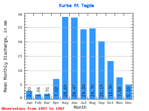
| Statistic | Jan | Feb | Mar | Apr | May | Jun | Jul | Aug | Sep | Oct | Nov | Dec | Annual |
|---|---|---|---|---|---|---|---|---|---|---|---|---|---|
| Mean | 2.80 | 1.67 | 1.91 | 7.02 | 28.68 | 28.46 | 24.32 | 24.70 | 20.19 | 13.30 | 7.58 | 5.10 | 164.99 |
| Standard Deviation | 1.30 | 0.81 | 0.94 | 4.34 | 8.87 | 15.81 | 10.29 | 12.84 | 9.00 | 4.07 | 2.21 | 1.99 | 56.60 |
| Min | 0.97 | 0.34 | 0.29 | 3.14 | 15.16 | 11.74 | 7.92 | 9.10 | 5.97 | 6.17 | 3.91 | 1.98 | 86.86 |
| Max | 5.68 | 4.11 | 4.33 | 24.13 | 56.96 | 100.24 | 56.81 | 61.03 | 50.55 | 23.97 | 14.32 | 10.73 | 377.40 |
| Coefficient of Variation | 0.46 | 0.49 | 0.49 | 0.62 | 0.31 | 0.56 | 0.42 | 0.52 | 0.45 | 0.31 | 0.29 | 0.39 | 0.34 |
 Return to R-Arctic Net Home Page