|
|
|||||||||||||||||
| Point ID: 6442 | Downloads | Plots | Site Data | Code: 7135 |
|
|
|||||||||||||||||
| Download | |
|---|---|
| Site Descriptor Information | Site Time Series Data |
| Link to all available data | |
| View: | Time Series | All |
| Units: | m3/s |
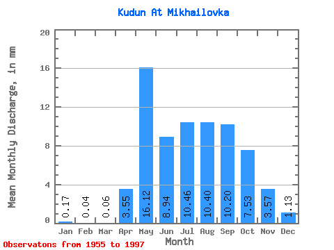
| Statistic | Jan | Feb | Mar | Apr | May | Jun | Jul | Aug | Sep | Oct | Nov | Dec | Annual |
|---|---|---|---|---|---|---|---|---|---|---|---|---|---|
| Mean | 0.17 | 0.04 | 0.07 | 3.55 | 16.12 | 8.94 | 10.46 | 10.39 | 10.20 | 7.53 | 3.57 | 1.13 | 71.72 |
| Standard Deviation | 0.26 | 0.15 | 0.25 | 2.98 | 6.86 | 4.20 | 6.44 | 5.37 | 6.19 | 3.75 | 2.07 | 0.87 | 25.67 |
| Min | 0.00 | 0.00 | 0.00 | 0.21 | 6.02 | 2.14 | 3.47 | 1.27 | 1.04 | 1.25 | 0.47 | 0.06 | 21.50 |
| Max | 1.16 | 0.75 | 1.46 | 17.04 | 35.54 | 20.97 | 32.30 | 31.24 | 30.71 | 17.85 | 11.31 | 3.82 | 139.13 |
| Coefficient of Variation | 1.57 | 3.75 | 3.79 | 0.84 | 0.43 | 0.47 | 0.62 | 0.52 | 0.61 | 0.50 | 0.58 | 0.77 | 0.36 |
 Return to R-Arctic Net Home Page