|
|
|||||||||||||||||
| Point ID: 6441 | Downloads | Plots | Site Data | Code: 7134 |
|
|
|||||||||||||||||
| Download | |
|---|---|
| Site Descriptor Information | Site Time Series Data |
| Link to all available data | |
| View: | Time Series | All |
| Units: | m3/s |
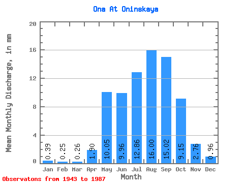
| Statistic | Jan | Feb | Mar | Apr | May | Jun | Jul | Aug | Sep | Oct | Nov | Dec | Annual |
|---|---|---|---|---|---|---|---|---|---|---|---|---|---|
| Mean | 0.39 | 0.25 | 0.26 | 1.90 | 10.05 | 9.96 | 12.86 | 16.00 | 15.02 | 9.15 | 2.76 | 0.96 | 79.10 |
| Standard Deviation | 0.27 | 0.21 | 0.23 | 1.89 | 3.75 | 7.02 | 8.33 | 11.34 | 9.85 | 4.49 | 1.31 | 0.57 | 33.12 |
| Min | 0.06 | 0.02 | 0.02 | 0.05 | 3.31 | 4.39 | 3.16 | 3.96 | 3.05 | 3.49 | 1.09 | 0.15 | 36.01 |
| Max | 1.19 | 0.68 | 0.72 | 7.38 | 19.00 | 48.29 | 48.85 | 46.38 | 49.31 | 24.76 | 6.86 | 2.25 | 165.45 |
| Coefficient of Variation | 0.69 | 0.85 | 0.89 | 0.99 | 0.37 | 0.70 | 0.65 | 0.71 | 0.66 | 0.49 | 0.48 | 0.60 | 0.42 |
 Return to R-Arctic Net Home Page