|
|
|||||||||||||||||
| Point ID: 6438 | Downloads | Plots | Site Data | Code: 7125 |
|
|
|||||||||||||||||
| Download | |
|---|---|
| Site Descriptor Information | Site Time Series Data |
| Link to all available data | |
| View: | Time Series | All |
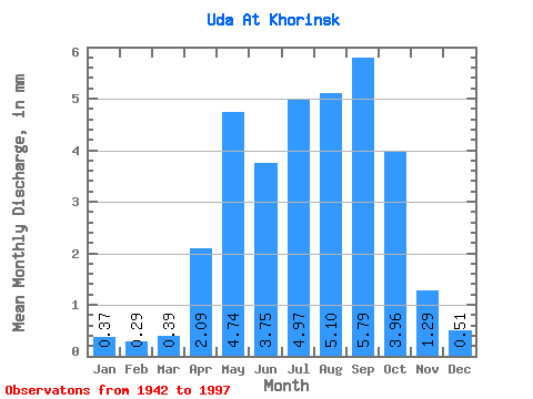
| Units: | m3/s |
| Statistic | Jan | Feb | Mar | Apr | May | Jun | Jul | Aug | Sep | Oct | Nov | Dec | Annual |
|---|---|---|---|---|---|---|---|---|---|---|---|---|---|
| Mean | 0.37 | 0.30 | 0.39 | 2.09 | 4.74 | 3.75 | 4.97 | 5.10 | 5.79 | 3.96 | 1.29 | 0.52 | 33.03 |
| Standard Deviation | 0.22 | 0.20 | 0.23 | 1.66 | 3.61 | 3.55 | 5.19 | 4.66 | 5.76 | 3.30 | 1.85 | 0.28 | 19.84 |
| Min | 0.11 | 0.05 | 0.06 | 0.37 | 0.69 | 0.62 | 0.68 | 0.87 | 0.85 | 0.72 | 0.34 | 0.19 | 8.58 |
| Max | 1.30 | 1.11 | 1.35 | 6.44 | 14.16 | 17.76 | 22.96 | 22.58 | 29.85 | 16.55 | 14.07 | 1.47 | 78.87 |
| Coefficient of Variation | 0.59 | 0.67 | 0.59 | 0.79 | 0.76 | 0.95 | 1.04 | 0.91 | 1.00 | 0.83 | 1.44 | 0.54 | 0.60 |
 Return to R-Arctic Net Home Page