|
|
|||||||||||||||||
| Point ID: 6422 | Downloads | Plots | Site Data | Code: 7087 |
|
|
|||||||||||||||||
| Download | |
|---|---|
| Site Descriptor Information | Site Time Series Data |
| Link to all available data | |
| View: | Time Series | All |
| Units: | m3/s |
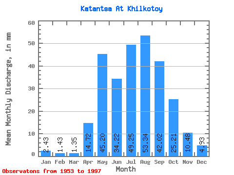
| Statistic | Jan | Feb | Mar | Apr | May | Jun | Jul | Aug | Sep | Oct | Nov | Dec | Annual |
|---|---|---|---|---|---|---|---|---|---|---|---|---|---|
| Mean | 2.43 | 1.44 | 1.35 | 14.72 | 45.20 | 34.22 | 49.24 | 53.34 | 42.02 | 25.21 | 10.48 | 4.93 | 283.45 |
| Standard Deviation | 1.73 | 1.27 | 1.11 | 8.73 | 19.67 | 22.40 | 35.77 | 35.50 | 20.64 | 12.50 | 6.01 | 2.58 | 113.35 |
| Min | 0.46 | 0.09 | 0.00 | 2.85 | 15.92 | 3.24 | 11.23 | 10.19 | 11.22 | 9.06 | 2.64 | 1.39 | 79.06 |
| Max | 7.34 | 6.50 | 4.62 | 34.48 | 83.25 | 106.00 | 170.53 | 195.80 | 99.16 | 69.35 | 31.91 | 15.03 | 589.13 |
| Coefficient of Variation | 0.71 | 0.88 | 0.82 | 0.59 | 0.43 | 0.66 | 0.73 | 0.67 | 0.49 | 0.50 | 0.57 | 0.52 | 0.40 |
 Return to R-Arctic Net Home Page