|
|
|||||||||||||||||
| Point ID: 6418 | Downloads | Plots | Site Data | Code: 7066 |
|
|
|||||||||||||||||
| Download | |
|---|---|
| Site Descriptor Information | Site Time Series Data |
| Link to all available data | |
| View: | Time Series | All |
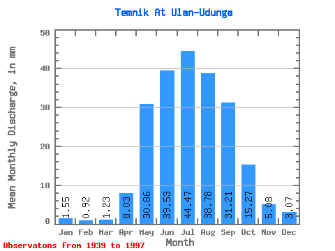
| Units: | m3/s |
| Statistic | Jan | Feb | Mar | Apr | May | Jun | Jul | Aug | Sep | Oct | Nov | Dec | Annual |
|---|---|---|---|---|---|---|---|---|---|---|---|---|---|
| Mean | 1.55 | 0.93 | 1.23 | 8.03 | 30.85 | 39.53 | 44.46 | 38.78 | 31.21 | 15.27 | 5.08 | 3.07 | 218.00 |
| Standard Deviation | 0.56 | 0.47 | 0.70 | 6.13 | 10.29 | 14.94 | 25.05 | 15.56 | 12.65 | 5.06 | 1.95 | 0.95 | 53.75 |
| Min | 0.32 | 0.01 | 0.00 | 0.95 | 11.75 | 12.41 | 13.01 | 15.22 | 15.22 | 7.58 | 1.74 | 1.32 | 133.53 |
| Max | 2.52 | 1.93 | 3.71 | 26.04 | 58.99 | 72.14 | 161.69 | 113.69 | 77.03 | 30.00 | 12.04 | 5.38 | 350.80 |
| Coefficient of Variation | 0.36 | 0.50 | 0.57 | 0.76 | 0.33 | 0.38 | 0.56 | 0.40 | 0.41 | 0.33 | 0.39 | 0.31 | 0.25 |
 Return to R-Arctic Net Home Page