|
|
|||||||||||||||||
| Point ID: 6417 | Downloads | Plots | Site Data | Code: 7064 |
|
|
|||||||||||||||||
| Download | |
|---|---|
| Site Descriptor Information | Site Time Series Data |
| Link to all available data | |
| View: | Time Series | All |
| Units: | m3/s |
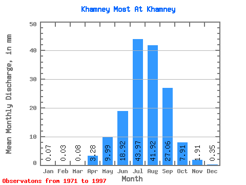
| Statistic | Jan | Feb | Mar | Apr | May | Jun | Jul | Aug | Sep | Oct | Nov | Dec | Annual |
|---|---|---|---|---|---|---|---|---|---|---|---|---|---|
| Mean | 0.07 | 0.03 | 0.08 | 3.28 | 9.99 | 18.92 | 43.96 | 41.91 | 27.06 | 7.91 | 1.91 | 0.35 | 154.33 |
| Standard Deviation | 0.11 | 0.06 | 0.10 | 1.82 | 4.97 | 14.83 | 27.97 | 22.63 | 19.96 | 2.93 | 0.81 | 0.28 | 59.54 |
| Min | 0.00 | 0.00 | 0.00 | 0.66 | 3.42 | 2.19 | 10.71 | 9.97 | 4.03 | 3.26 | 0.55 | 0.00 | 64.14 |
| Max | 0.46 | 0.20 | 0.38 | 7.34 | 24.40 | 61.85 | 120.51 | 110.10 | 96.48 | 15.70 | 3.92 | 1.14 | 253.58 |
| Coefficient of Variation | 1.70 | 2.05 | 1.34 | 0.55 | 0.50 | 0.78 | 0.64 | 0.54 | 0.74 | 0.37 | 0.42 | 0.81 | 0.39 |
 Return to R-Arctic Net Home Page