|
|
|||||||||||||||||
| Point ID: 6410 | Downloads | Plots | Site Data | Other Close Sites | Code: 7041 |
|
|
|||||||||||||||||
| Download | |
|---|---|
| Site Descriptor Information | Site Time Series Data |
| Link to all available data | |
| View: | Time Series | All |
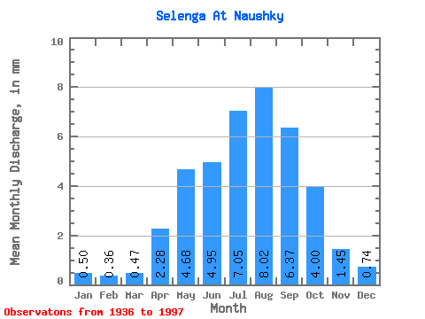
| Units: | m3/s |
| Statistic | Jan | Feb | Mar | Apr | May | Jun | Jul | Aug | Sep | Oct | Nov | Dec | Annual |
|---|---|---|---|---|---|---|---|---|---|---|---|---|---|
| Mean | 0.49 | 0.36 | 0.47 | 2.28 | 4.67 | 4.95 | 7.05 | 8.02 | 6.37 | 4.00 | 1.45 | 0.74 | 40.78 |
| Standard Deviation | 0.27 | 0.19 | 0.24 | 0.81 | 1.45 | 1.78 | 3.69 | 4.98 | 3.32 | 1.29 | 0.51 | 0.31 | 13.95 |
| Min | 0.27 | 0.16 | 0.20 | 0.43 | 2.18 | 2.28 | 2.15 | 2.72 | 1.81 | 1.51 | 0.60 | 0.41 | 20.37 |
| Max | 1.53 | 0.86 | 1.24 | 4.18 | 8.68 | 8.45 | 16.62 | 30.20 | 14.89 | 6.71 | 2.67 | 1.85 | 88.65 |
| Coefficient of Variation | 0.54 | 0.51 | 0.52 | 0.35 | 0.31 | 0.36 | 0.52 | 0.62 | 0.52 | 0.32 | 0.35 | 0.41 | 0.34 |
| Other Close Sites | ||||||
|---|---|---|---|---|---|---|
| PointID | Latitude | Longitude | Drainage Area | Source | Name | |
| 6415 | "Dzhida At Dzhida" | 50.63 | 1191752 | SHI | 21.00 | |
 Return to R-Arctic Net Home Page