|
|
|||||||||||||||||
| Point ID: 6409 | Downloads | Plots | Site Data | Code: 7038 |
|
|
|||||||||||||||||
| Download | |
|---|---|
| Site Descriptor Information | Site Time Series Data |
| Link to all available data | |
| View: | Time Series | All |
| Units: | m3/s |
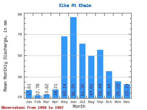
| Statistic | Jan | Feb | Mar | Apr | May | Jun | Jul | Aug | Sep | Oct | Nov | Dec | Annual |
|---|---|---|---|---|---|---|---|---|---|---|---|---|---|
| Mean | 17.60 | 12.89 | 13.62 | 18.21 | 68.13 | 86.20 | 61.29 | 49.80 | 55.49 | 35.43 | 26.04 | 23.13 | 466.75 |
| Standard Deviation | 3.64 | 3.43 | 2.80 | 3.98 | 17.31 | 30.36 | 23.48 | 15.47 | 71.24 | 10.28 | 5.60 | 4.37 | 104.16 |
| Min | 10.63 | 4.75 | 8.10 | 12.11 | 43.40 | 31.58 | 27.70 | 22.47 | 21.30 | 18.93 | 16.24 | 13.53 | 306.50 |
| Max | 24.62 | 19.91 | 19.09 | 28.30 | 120.36 | 172.80 | 145.91 | 79.72 | 481.16 | 63.26 | 39.92 | 32.63 | 872.43 |
| Coefficient of Variation | 0.21 | 0.27 | 0.20 | 0.22 | 0.25 | 0.35 | 0.38 | 0.31 | 1.28 | 0.29 | 0.21 | 0.19 | 0.22 |
 Return to R-Arctic Net Home Page