|
|
|||||||||||||||||
| Point ID: 6403 | Downloads | Plots | Site Data | Code: 7017 |
|
|
|||||||||||||||||
| Download | |
|---|---|
| Site Descriptor Information | Site Time Series Data |
| Link to all available data | |
| View: | Time Series | All |
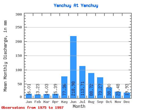
| Units: | m3/s |
| Statistic | Jan | Feb | Mar | Apr | May | Jun | Jul | Aug | Sep | Oct | Nov | Dec | Annual |
|---|---|---|---|---|---|---|---|---|---|---|---|---|---|
| Mean | 16.01 | 13.34 | 14.03 | 15.39 | 77.35 | 218.98 | 113.70 | 88.70 | 73.27 | 38.30 | 23.48 | 19.92 | 712.89 |
| Standard Deviation | 1.98 | 1.59 | 1.42 | 2.49 | 30.47 | 54.31 | 53.84 | 36.08 | 22.28 | 8.80 | 4.66 | 3.44 | 120.69 |
| Min | 12.38 | 10.88 | 11.45 | 12.48 | 36.61 | 131.50 | 45.70 | 36.61 | 48.03 | 25.55 | 15.34 | 14.86 | 492.29 |
| Max | 19.97 | 16.88 | 16.56 | 23.78 | 146.18 | 337.67 | 218.17 | 181.32 | 138.16 | 69.53 | 40.19 | 29.24 | 1024.30 |
| Coefficient of Variation | 0.12 | 0.12 | 0.10 | 0.16 | 0.39 | 0.25 | 0.47 | 0.41 | 0.30 | 0.23 | 0.20 | 0.17 | 0.17 |
 Return to R-Arctic Net Home Page