|
|
|||||||||||||||||
| Point ID: 639 | Downloads | Plots | Site Data | Code: 07AH002 |
|
|
|||||||||||||||||
| Download | |
|---|---|
| Site Descriptor Information | Site Time Series Data |
| Link to all available data | |
| View: | Time Series | All |
| Units: | m3/s |
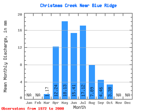
| Statistic | Jan | Feb | Mar | Apr | May | Jun | Jul | Aug | Sep | Oct | Nov | Dec | Annual |
|---|---|---|---|---|---|---|---|---|---|---|---|---|---|
| Mean | 1.17 | 12.25 | 18.12 | 15.41 | 17.12 | 7.89 | 4.46 | 3.38 | |||||
| Standard Deviation | 1.22 | 10.16 | 16.54 | 12.19 | 13.68 | 8.15 | 3.67 | 2.43 | |||||
| Min | 0.09 | 1.82 | 2.08 | 0.70 | 0.40 | 0.30 | 0.11 | 0.16 | |||||
| Max | 6.63 | 42.30 | 75.16 | 45.24 | 54.26 | 32.34 | 13.82 | 11.18 | |||||
| Coefficient of Variation | 1.04 | 0.83 | 0.91 | 0.79 | 0.80 | 1.03 | 0.82 | 0.72 |
 Return to R-Arctic Net Home Page