|
|
|||||||||||||||||
| Point ID: 638 | Downloads | Plots | Site Data | Code: 07AH001 |
|
|
|||||||||||||||||
| Download | |
|---|---|
| Site Descriptor Information | Site Time Series Data |
| Link to all available data | |
| View: | Time Series | All |
| Units: | m3/s |
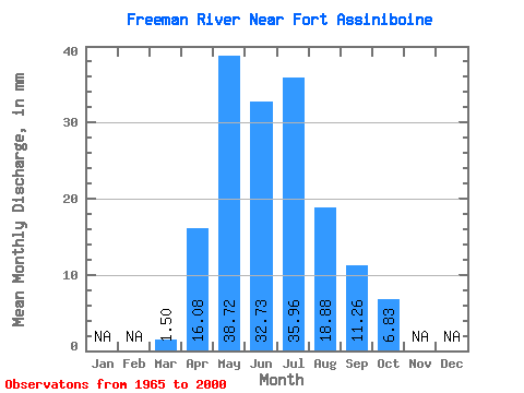
| Statistic | Jan | Feb | Mar | Apr | May | Jun | Jul | Aug | Sep | Oct | Nov | Dec | Annual |
|---|---|---|---|---|---|---|---|---|---|---|---|---|---|
| Mean | 1.50 | 16.08 | 38.72 | 32.73 | 35.96 | 18.88 | 11.26 | 6.82 | |||||
| Standard Deviation | 1.18 | 10.77 | 25.82 | 22.07 | 30.95 | 16.84 | 9.05 | 4.49 | |||||
| Min | 0.17 | 3.89 | 7.84 | 3.04 | 2.77 | 1.92 | 1.03 | 1.00 | |||||
| Max | 7.45 | 41.69 | 118.57 | 103.37 | 156.49 | 65.01 | 32.79 | 20.33 | |||||
| Coefficient of Variation | 0.79 | 0.67 | 0.67 | 0.67 | 0.86 | 0.89 | 0.80 | 0.66 |
 Return to R-Arctic Net Home Page