|
|
|||||||||||||||||
| Point ID: 6341 | Downloads | Plots | Site Data | Code: 3811 |
|
|
|||||||||||||||||
| Download | |
|---|---|
| Site Descriptor Information | Site Time Series Data |
| Link to all available data | |
| View: | Time Series | All |
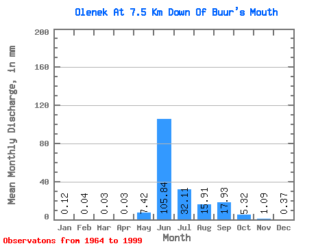
| Units: | m3/s |
| Statistic | Jan | Feb | Mar | Apr | May | Jun | Jul | Aug | Sep | Oct | Nov | Dec | Annual |
|---|---|---|---|---|---|---|---|---|---|---|---|---|---|
| Mean | 0.12 | 0.04 | 0.03 | 0.03 | 7.42 | 105.84 | 32.10 | 15.91 | 17.93 | 5.32 | 1.09 | 0.37 | 186.93 |
| Standard Deviation | 0.07 | 0.02 | 0.02 | 0.01 | 15.40 | 31.66 | 16.95 | 10.29 | 10.70 | 3.03 | 0.35 | 0.16 | 52.44 |
| Min | 0.03 | 0.01 | 0.01 | 0.00 | 0.02 | 61.40 | 8.10 | 1.58 | 1.21 | 0.60 | 0.28 | 0.10 | 102.81 |
| Max | 0.41 | 0.08 | 0.06 | 0.05 | 74.52 | 202.91 | 75.06 | 44.90 | 57.08 | 13.31 | 1.91 | 0.86 | 293.06 |
| Coefficient of Variation | 0.58 | 0.38 | 0.47 | 0.52 | 2.08 | 0.30 | 0.53 | 0.65 | 0.60 | 0.57 | 0.32 | 0.42 | 0.28 |
 Return to R-Arctic Net Home Page