|
|
|||||||||||||||||
| Point ID: 6339 | Downloads | Plots | Site Data | Code: 3802 |
|
|
|||||||||||||||||
| Download | |
|---|---|
| Site Descriptor Information | Site Time Series Data |
| Link to all available data | |
| View: | Time Series | All |
| Units: | m3/s |
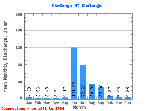
| Statistic | Jan | Feb | Mar | Apr | May | Jun | Jul | Aug | Sep | Oct | Nov | Dec | Annual |
|---|---|---|---|---|---|---|---|---|---|---|---|---|---|
| Mean | 4.39 | 2.99 | 3.43 | 2.91 | 4.17 | 121.48 | 78.21 | 34.92 | 28.00 | 8.27 | 5.43 | 4.88 | 288.83 |
| Standard Deviation | 0.55 | 0.58 | 0.70 | 0.68 | 1.47 | 23.79 | 64.00 | 12.54 | 7.12 | 1.11 | 0.48 | 0.82 | 13.44 |
| Min | 3.78 | 2.56 | 2.81 | 2.27 | 2.72 | 71.72 | 28.14 | 21.13 | 15.46 | 7.03 | 4.89 | 3.75 | 273.34 |
| Max | 4.83 | 3.66 | 4.20 | 3.63 | 5.66 | 165.44 | 394.18 | 83.09 | 48.51 | 9.66 | 5.99 | 5.67 | 297.28 |
| Coefficient of Variation | 0.12 | 0.20 | 0.21 | 0.23 | 0.35 | 0.20 | 0.82 | 0.36 | 0.25 | 0.13 | 0.09 | 0.17 | 0.05 |
 Return to R-Arctic Net Home Page