|
|
|||||||||||||||||
| Point ID: 6326 | Downloads | Plots | Site Data | Code: 3576 |
|
|
|||||||||||||||||
| Download | |
|---|---|
| Site Descriptor Information | Site Time Series Data |
| Link to all available data | |
| View: | Time Series | All |
| Units: | m3/s |
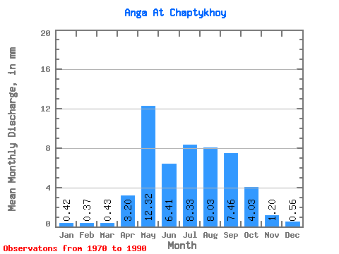
| Statistic | Jan | Feb | Mar | Apr | May | Jun | Jul | Aug | Sep | Oct | Nov | Dec | Annual |
|---|---|---|---|---|---|---|---|---|---|---|---|---|---|
| Mean | 0.42 | 0.37 | 0.43 | 3.20 | 12.31 | 6.42 | 8.33 | 8.03 | 7.46 | 4.03 | 1.20 | 0.56 | 66.94 |
| Standard Deviation | 0.64 | 0.49 | 0.46 | 2.39 | 9.60 | 4.69 | 9.29 | 7.28 | 5.04 | 2.78 | 0.90 | 0.63 | 25.18 |
| Min | 0.00 | 0.00 | 0.00 | 0.68 | 0.17 | 0.03 | 0.01 | 2.22 | 1.90 | 0.89 | 0.11 | 0.02 | 38.90 |
| Max | 2.04 | 1.54 | 1.16 | 8.45 | 32.71 | 17.21 | 33.50 | 27.35 | 18.09 | 9.97 | 2.88 | 1.97 | 107.08 |
| Coefficient of Variation | 1.52 | 1.34 | 1.08 | 0.75 | 0.78 | 0.73 | 1.11 | 0.91 | 0.68 | 0.69 | 0.74 | 1.13 | 0.38 |
 Return to R-Arctic Net Home Page