|
|
|||||||||||||||||
| Point ID: 6322 | Downloads | Plots | Site Data | Code: 3566 |
|
|
|||||||||||||||||
| Download | |
|---|---|
| Site Descriptor Information | Site Time Series Data |
| Link to all available data | |
| View: | Time Series | All |
| Units: | m3/s |
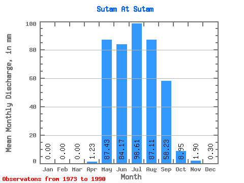
| Statistic | Jan | Feb | Mar | Apr | May | Jun | Jul | Aug | Sep | Oct | Nov | Dec | Annual |
|---|---|---|---|---|---|---|---|---|---|---|---|---|---|
| Mean | 0.00 | 0.00 | 0.00 | 1.23 | 87.42 | 84.17 | 98.60 | 87.10 | 58.23 | 8.95 | 1.91 | 0.30 | 420.95 |
| Standard Deviation | 0.00 | 0.00 | 0.00 | 3.00 | 53.62 | 54.73 | 51.05 | 56.19 | 37.26 | 6.66 | 3.33 | 1.03 | 182.21 |
| Min | 0.00 | 0.00 | 0.00 | 0.00 | 3.72 | 1.50 | 2.92 | 5.29 | 1.80 | 0.40 | 0.00 | 0.00 | 15.49 |
| Max | 0.00 | 0.00 | 0.00 | 10.91 | 169.78 | 180.45 | 205.66 | 211.42 | 139.52 | 22.36 | 10.11 | 3.58 | 641.54 |
| Coefficient of Variation | 2.44 | 0.61 | 0.65 | 0.52 | 0.65 | 0.64 | 0.74 | 1.75 | 3.41 | 0.43 |
 Return to R-Arctic Net Home Page