|
|
|||||||||||||||||
| Point ID: 6321 | Downloads | Plots | Site Data | Code: 3565 |
|
|
|||||||||||||||||
| Download | |
|---|---|
| Site Descriptor Information | Site Time Series Data |
| Link to all available data | |
| View: | Time Series | All |
| Units: | m3/s |
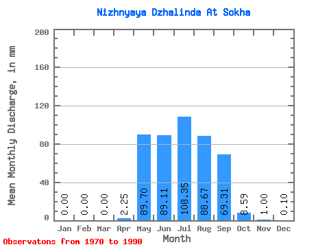
| Statistic | Jan | Feb | Mar | Apr | May | Jun | Jul | Aug | Sep | Oct | Nov | Dec | Annual |
|---|---|---|---|---|---|---|---|---|---|---|---|---|---|
| Mean | 0.00 | 0.00 | 0.00 | 2.25 | 89.69 | 89.11 | 108.33 | 88.66 | 69.31 | 8.59 | 0.99 | 0.10 | 469.10 |
| Standard Deviation | 0.00 | 0.00 | 0.00 | 6.96 | 50.81 | 55.03 | 58.45 | 63.12 | 54.63 | 5.49 | 2.36 | 0.35 | 195.65 |
| Min | 0.00 | 0.00 | 0.00 | 0.00 | 0.62 | 5.05 | 0.48 | 0.56 | 0.63 | 0.13 | 0.00 | 0.00 | 7.52 |
| Max | 0.00 | 0.00 | 0.00 | 25.27 | 160.40 | 181.17 | 211.14 | 233.69 | 210.36 | 19.34 | 7.97 | 1.16 | 752.43 |
| Coefficient of Variation | 3.09 | 0.57 | 0.62 | 0.54 | 0.71 | 0.79 | 0.64 | 2.37 | 3.32 | 0.42 |
 Return to R-Arctic Net Home Page