|
|
|||||||||||||||||
| Point ID: 6314 | Downloads | Plots | Site Data | Code: 3554 |
|
|
|||||||||||||||||
| Download | |
|---|---|
| Site Descriptor Information | Site Time Series Data |
| Link to all available data | |
| View: | Time Series | All |
| Units: | m3/s |
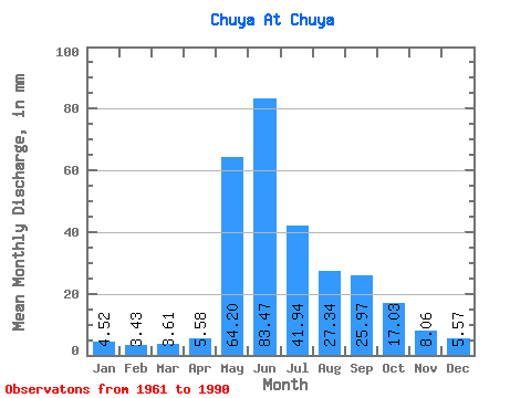
| Statistic | Jan | Feb | Mar | Apr | May | Jun | Jul | Aug | Sep | Oct | Nov | Dec | Annual |
|---|---|---|---|---|---|---|---|---|---|---|---|---|---|
| Mean | 4.52 | 3.46 | 3.61 | 5.58 | 64.19 | 83.47 | 41.94 | 27.34 | 25.97 | 17.02 | 8.06 | 5.57 | 278.59 |
| Standard Deviation | 3.29 | 2.44 | 2.55 | 5.22 | 34.36 | 52.79 | 25.75 | 18.58 | 15.78 | 9.36 | 3.99 | 3.39 | 145.66 |
| Min | 0.94 | 0.92 | 0.53 | 0.54 | 19.50 | 19.02 | 8.89 | 8.05 | 8.92 | 6.45 | 1.89 | 1.22 | 122.80 |
| Max | 11.86 | 7.76 | 9.13 | 23.38 | 155.73 | 214.12 | 94.46 | 62.73 | 61.28 | 39.01 | 15.21 | 12.88 | 575.67 |
| Coefficient of Variation | 0.73 | 0.70 | 0.71 | 0.94 | 0.54 | 0.63 | 0.61 | 0.68 | 0.61 | 0.55 | 0.49 | 0.61 | 0.52 |
 Return to R-Arctic Net Home Page