|
|
|||||||||||||||||
| Point ID: 6309 | Downloads | Plots | Site Data | Code: 3529 |
|
|
|||||||||||||||||
| Download | |
|---|---|
| Site Descriptor Information | Site Time Series Data |
| Link to all available data | |
| View: | Time Series | All |
| Units: | m3/s |
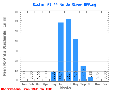
| Statistic | Jan | Feb | Mar | Apr | May | Jun | Jul | Aug | Sep | Oct | Nov | Dec | Annual |
|---|---|---|---|---|---|---|---|---|---|---|---|---|---|
| Mean | 0.00 | 0.00 | 0.00 | 0.00 | 9.35 | 58.21 | 61.73 | 42.00 | 15.15 | 4.23 | 0.54 | 0.00 | 190.65 |
| Standard Deviation | 0.00 | 0.00 | 0.00 | 0.01 | 14.43 | 28.42 | 27.75 | 21.49 | 7.27 | 2.02 | 0.37 | 0.00 | 60.58 |
| Min | 0.00 | 0.00 | 0.00 | 0.00 | 0.37 | 15.58 | 21.80 | 17.41 | 6.34 | 2.19 | 0.02 | 0.00 | 108.53 |
| Max | 0.00 | 0.00 | 0.00 | 0.04 | 84.29 | 112.60 | 145.46 | 109.02 | 40.65 | 14.05 | 1.67 | 0.02 | 373.26 |
| Coefficient of Variation | 4.18 | 1.54 | 0.49 | 0.45 | 0.51 | 0.48 | 0.48 | 0.70 | 2.38 | 0.32 |
 Return to R-Arctic Net Home Page