|
|
|||||||||||||||||
| Point ID: 6308 | Downloads | Plots | Site Data | Code: 3518 |
|
|
|||||||||||||||||
| Download | |
|---|---|
| Site Descriptor Information | Site Time Series Data |
| Link to all available data | |
| View: | Time Series | All |
| Units: | m3/s |
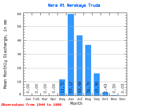
| Statistic | Jan | Feb | Mar | Apr | May | Jun | Jul | Aug | Sep | Oct | Nov | Dec | Annual |
|---|---|---|---|---|---|---|---|---|---|---|---|---|---|
| Mean | 0.00 | 0.00 | 0.00 | 0.00 | 11.72 | 59.12 | 43.47 | 36.69 | 15.95 | 2.42 | 0.30 | 0.03 | 169.12 |
| Standard Deviation | 0.00 | 0.00 | 0.00 | 0.00 | 12.41 | 27.11 | 19.60 | 16.26 | 9.39 | 1.04 | 0.18 | 0.04 | 46.85 |
| Min | 0.00 | 0.00 | 0.00 | 0.00 | 0.46 | 10.89 | 15.25 | 8.11 | 4.24 | 0.66 | 0.03 | 0.00 | 86.69 |
| Max | 0.01 | 0.00 | 0.00 | 0.00 | 57.76 | 131.34 | 96.43 | 79.38 | 47.07 | 5.90 | 0.93 | 0.17 | 270.18 |
| Coefficient of Variation | 4.43 | 1.06 | 0.46 | 0.45 | 0.44 | 0.59 | 0.43 | 0.61 | 1.61 | 0.28 |
 Return to R-Arctic Net Home Page