|
|
|||||||||||||||||
| Point ID: 630 | Downloads | Plots | Site Data | Code: 07AG001 |
|
|
|||||||||||||||||
| Download | |
|---|---|
| Site Descriptor Information | Site Time Series Data |
| Link to all available data | |
| View: | Time Series | All |
| Units: | m3/s |
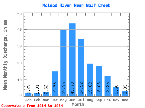
| Statistic | Jan | Feb | Mar | Apr | May | Jun | Jul | Aug | Sep | Oct | Nov | Dec | Annual |
|---|---|---|---|---|---|---|---|---|---|---|---|---|---|
| Mean | 2.26 | 1.91 | 2.59 | 14.77 | 39.44 | 43.14 | 33.88 | 19.37 | 17.83 | 12.19 | 5.43 | 3.29 | 197.46 |
| Standard Deviation | 1.04 | 0.92 | 1.42 | 8.12 | 20.60 | 28.73 | 26.68 | 14.85 | 16.54 | 8.02 | 2.59 | 1.44 | 71.85 |
| Min | 0.47 | 0.09 | 0.11 | 3.91 | 8.28 | 12.65 | 7.60 | 5.73 | 3.85 | 3.74 | 1.89 | 0.89 | 94.53 |
| Max | 5.39 | 4.21 | 7.26 | 32.33 | 88.28 | 164.31 | 116.71 | 74.69 | 81.75 | 44.56 | 12.90 | 6.49 | 359.33 |
| Coefficient of Variation | 0.46 | 0.48 | 0.55 | 0.55 | 0.52 | 0.67 | 0.79 | 0.77 | 0.93 | 0.66 | 0.48 | 0.44 | 0.36 |
 Return to R-Arctic Net Home Page