|
|
|||||||||||||||||
| Point ID: 6296 | Downloads | Plots | Site Data | Code: 3443 |
|
|
|||||||||||||||||
| Download | |
|---|---|
| Site Descriptor Information | Site Time Series Data |
| Link to all available data | |
| View: | Time Series | All |
| Units: | m3/s |
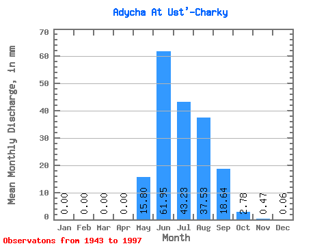
| Statistic | Jan | Feb | Mar | Apr | May | Jun | Jul | Aug | Sep | Oct | Nov | Dec | Annual |
|---|---|---|---|---|---|---|---|---|---|---|---|---|---|
| Mean | 0.00 | 0.00 | 0.00 | 0.00 | 15.80 | 61.95 | 43.23 | 37.53 | 18.64 | 2.78 | 0.47 | 0.06 | 179.87 |
| Standard Deviation | 0.00 | 0.00 | 0.00 | 0.00 | 9.64 | 26.43 | 15.64 | 17.31 | 11.04 | 1.74 | 0.21 | 0.06 | 48.82 |
| Min | 0.00 | 0.00 | 0.00 | 0.00 | 0.80 | 3.57 | 22.11 | 8.93 | 3.92 | 0.82 | 0.02 | 0.00 | 44.65 |
| Max | 0.01 | 0.00 | 0.00 | 0.01 | 49.70 | 124.69 | 91.30 | 89.77 | 47.18 | 9.89 | 0.99 | 0.33 | 316.09 |
| Coefficient of Variation | 3.73 | 4.47 | 0.61 | 0.43 | 0.36 | 0.46 | 0.59 | 0.63 | 0.43 | 0.97 | 0.27 |
 Return to R-Arctic Net Home Page