|
|
|||||||||||||||||
| Point ID: 6295 | Downloads | Plots | Site Data | Code: 3430 |
|
|
|||||||||||||||||
| Download | |
|---|---|
| Site Descriptor Information | Site Time Series Data |
| Link to all available data | |
| View: | Time Series | All |
| Units: | m3/s |
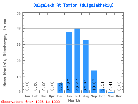
| Statistic | Jan | Feb | Mar | Apr | May | Jun | Jul | Aug | Sep | Oct | Nov | Dec | Annual |
|---|---|---|---|---|---|---|---|---|---|---|---|---|---|
| Mean | 0.00 | 0.00 | 0.00 | 0.00 | 5.98 | 37.87 | 40.46 | 32.91 | 13.87 | 2.51 | 0.41 | 0.03 | 133.33 |
| Standard Deviation | 0.00 | 0.00 | 0.00 | 0.00 | 4.78 | 20.16 | 19.55 | 16.27 | 7.22 | 0.97 | 0.24 | 0.04 | 43.07 |
| Min | 0.00 | 0.00 | 0.00 | 0.00 | 0.05 | 8.24 | 13.45 | 2.54 | 5.33 | 0.95 | 0.00 | 0.00 | 52.84 |
| Max | 0.03 | 0.00 | 0.00 | 0.00 | 24.32 | 94.79 | 86.50 | 71.26 | 37.09 | 4.54 | 1.06 | 0.19 | 235.70 |
| Coefficient of Variation | 5.71 | 0.80 | 0.53 | 0.48 | 0.49 | 0.52 | 0.39 | 0.58 | 1.30 | 0.32 |
 Return to R-Arctic Net Home Page