|
|
|||||||||||||||||
| Point ID: 6286 | Downloads | Plots | Site Data | Code: 3391 |
|
|
|||||||||||||||||
| Download | |
|---|---|
| Site Descriptor Information | Site Time Series Data |
| Link to all available data | |
| View: | Time Series | All |
| Units: | m3/s |
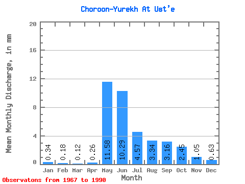
| Statistic | Jan | Feb | Mar | Apr | May | Jun | Jul | Aug | Sep | Oct | Nov | Dec | Annual |
|---|---|---|---|---|---|---|---|---|---|---|---|---|---|
| Mean | 0.34 | 0.18 | 0.12 | 0.26 | 11.58 | 10.29 | 4.57 | 3.34 | 3.16 | 2.45 | 1.05 | 0.63 | 37.30 |
| Standard Deviation | 0.69 | 0.55 | 0.39 | 0.40 | 5.61 | 7.22 | 3.07 | 2.15 | 1.69 | 1.50 | 0.75 | 0.73 | 19.23 |
| Min | 0.00 | 0.00 | 0.00 | 0.00 | 3.82 | 1.90 | 1.06 | 0.97 | 0.99 | 1.00 | 0.17 | 0.00 | 12.82 |
| Max | 2.91 | 2.48 | 1.72 | 1.60 | 23.11 | 30.52 | 11.45 | 8.77 | 6.87 | 6.73 | 3.23 | 3.02 | 87.41 |
| Coefficient of Variation | 2.06 | 3.07 | 3.26 | 1.53 | 0.48 | 0.70 | 0.67 | 0.64 | 0.54 | 0.61 | 0.71 | 1.15 | 0.52 |
 Return to R-Arctic Net Home Page