|
|
|||||||||||||||||
| Point ID: 6285 | Downloads | Plots | Site Data | Code: 3390 |
|
|
|||||||||||||||||
| Download | |
|---|---|
| Site Descriptor Information | Site Time Series Data |
| Link to all available data | |
| View: | Time Series | All |
| Units: | m3/s |
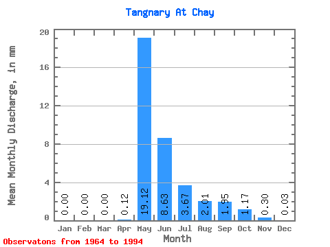
| Statistic | Jan | Feb | Mar | Apr | May | Jun | Jul | Aug | Sep | Oct | Nov | Dec | Annual |
|---|---|---|---|---|---|---|---|---|---|---|---|---|---|
| Mean | 0.00 | 0.00 | 0.00 | 0.12 | 19.12 | 8.63 | 3.67 | 2.01 | 1.95 | 1.17 | 0.30 | 0.03 | 34.71 |
| Standard Deviation | 0.01 | 0.00 | 0.00 | 0.54 | 13.99 | 5.11 | 2.25 | 1.67 | 1.57 | 0.61 | 0.17 | 0.06 | 19.72 |
| Min | 0.00 | 0.00 | 0.00 | 0.00 | 0.01 | 1.63 | 0.81 | 0.68 | 0.70 | 0.39 | 0.03 | 0.00 | 9.79 |
| Max | 0.05 | 0.00 | 0.00 | 2.84 | 59.05 | 21.87 | 9.07 | 8.97 | 7.51 | 2.65 | 0.78 | 0.25 | 86.85 |
| Coefficient of Variation | 5.38 | 4.51 | 0.73 | 0.59 | 0.61 | 0.83 | 0.80 | 0.52 | 0.59 | 2.48 | 0.57 |
 Return to R-Arctic Net Home Page