|
|
|||||||||||||||||
| Point ID: 6278 | Downloads | Plots | Site Data | Code: 3365 |
|
|
|||||||||||||||||
| Download | |
|---|---|
| Site Descriptor Information | Site Time Series Data |
| Link to all available data | |
| View: | Time Series | All |
| Units: | m3/s |
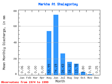
| Statistic | Jan | Feb | Mar | Apr | May | Jun | Jul | Aug | Sep | Oct | Nov | Dec | Annual |
|---|---|---|---|---|---|---|---|---|---|---|---|---|---|
| Mean | 0.06 | 0.00 | 0.00 | 0.00 | 53.98 | 74.19 | 26.43 | 16.09 | 13.78 | 3.80 | 0.93 | 0.25 | 192.19 |
| Standard Deviation | 0.23 | 0.00 | 0.00 | 0.00 | 36.83 | 37.55 | 20.43 | 17.53 | 11.34 | 3.84 | 1.43 | 0.69 | 53.64 |
| Min | 0.00 | 0.00 | 0.00 | 0.00 | 0.66 | 20.27 | 1.80 | 0.97 | 1.96 | 0.42 | 0.02 | 0.00 | 102.00 |
| Max | 0.99 | 0.00 | 0.00 | 0.00 | 151.59 | 151.75 | 90.08 | 75.15 | 39.74 | 11.86 | 4.90 | 3.04 | 302.67 |
| Coefficient of Variation | 4.11 | 0.68 | 0.51 | 0.77 | 1.09 | 0.82 | 1.01 | 1.54 | 2.77 | 0.28 |
 Return to R-Arctic Net Home Page