|
|
|||||||||||||||||
| Point ID: 6273 | Downloads | Plots | Site Data | Code: 3344 |
|
|
|||||||||||||||||
| Download | |
|---|---|
| Site Descriptor Information | Site Time Series Data |
| Link to all available data | |
| View: | Time Series | All |
| Units: | m3/s |
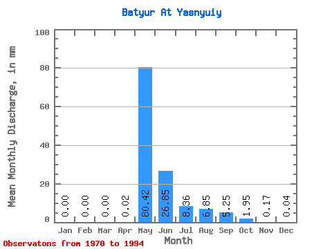
| Statistic | Jan | Feb | Mar | Apr | May | Jun | Jul | Aug | Sep | Oct | Nov | Dec | Annual |
|---|---|---|---|---|---|---|---|---|---|---|---|---|---|
| Mean | 0.00 | 0.00 | 0.00 | 0.02 | 80.41 | 26.85 | 8.36 | 6.85 | 5.25 | 1.94 | 0.17 | 0.04 | 128.62 |
| Standard Deviation | 0.01 | 0.00 | 0.00 | 0.08 | 27.67 | 20.42 | 13.40 | 16.42 | 7.42 | 2.05 | 0.17 | 0.06 | 46.16 |
| Min | 0.00 | 0.00 | 0.00 | 0.00 | 40.49 | 2.15 | 0.78 | 0.06 | 0.04 | 0.07 | 0.01 | 0.00 | 49.50 |
| Max | 0.03 | 0.00 | 0.00 | 0.40 | 145.78 | 78.99 | 52.85 | 74.40 | 27.07 | 6.23 | 0.64 | 0.25 | 232.36 |
| Coefficient of Variation | 2.07 | 4.13 | 0.34 | 0.76 | 1.60 | 2.40 | 1.41 | 1.05 | 1.04 | 1.56 | 0.36 |
 Return to R-Arctic Net Home Page