|
|
|||||||||||||||||
| Point ID: 6251 | Downloads | Plots | Site Data | Code: 3280 |
|
|
|||||||||||||||||
| Download | |
|---|---|
| Site Descriptor Information | Site Time Series Data |
| Link to all available data | |
| View: | Time Series | All |
| Units: | m3/s |
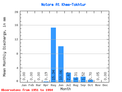
| Statistic | Jan | Feb | Mar | Apr | May | Jun | Jul | Aug | Sep | Oct | Nov | Dec | Annual |
|---|---|---|---|---|---|---|---|---|---|---|---|---|---|
| Mean | 0.00 | 0.00 | 0.00 | 0.19 | 15.34 | 10.06 | 2.67 | 1.31 | 1.52 | 0.70 | 0.05 | 0.00 | 31.66 |
| Standard Deviation | 0.00 | 0.00 | 0.00 | 0.74 | 10.09 | 7.87 | 3.53 | 2.78 | 2.35 | 1.22 | 0.09 | 0.00 | 18.69 |
| Min | 0.00 | 0.00 | 0.00 | 0.00 | 0.62 | 0.33 | 0.11 | 0.03 | 0.01 | 0.00 | 0.00 | 0.00 | 1.27 |
| Max | 0.00 | 0.00 | 0.00 | 4.13 | 41.50 | 42.77 | 19.48 | 15.37 | 10.30 | 5.80 | 0.35 | 0.02 | 74.56 |
| Coefficient of Variation | 3.89 | 0.66 | 0.78 | 1.32 | 2.12 | 1.55 | 1.75 | 1.74 | 3.79 | 0.59 |
 Return to R-Arctic Net Home Page