|
|
|||||||||||||||||
| Point ID: 6240 | Downloads | Plots | Site Data | Code: 3246 |
|
|
|||||||||||||||||
| Download | |
|---|---|
| Site Descriptor Information | Site Time Series Data |
| Link to all available data | |
| View: | Time Series | All |
| Units: | m3/s |
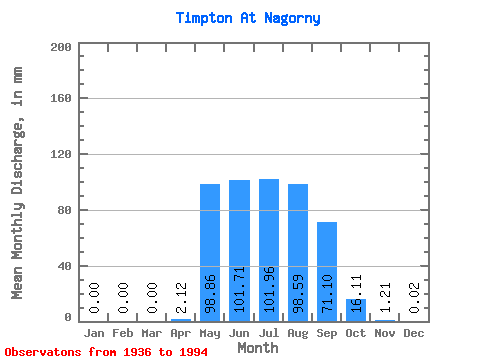
| Statistic | Jan | Feb | Mar | Apr | May | Jun | Jul | Aug | Sep | Oct | Nov | Dec | Annual |
|---|---|---|---|---|---|---|---|---|---|---|---|---|---|
| Mean | 0.00 | 0.00 | 0.00 | 2.12 | 98.85 | 101.71 | 101.95 | 98.58 | 71.10 | 16.11 | 1.21 | 0.02 | 483.88 |
| Standard Deviation | 0.00 | 0.00 | 0.00 | 6.02 | 42.81 | 55.17 | 53.81 | 55.68 | 36.05 | 11.04 | 2.48 | 0.06 | 115.18 |
| Min | 0.00 | 0.00 | 0.00 | 0.00 | 34.25 | 21.82 | 5.85 | 7.21 | 16.53 | 2.62 | 0.00 | 0.00 | 259.95 |
| Max | 0.00 | 0.00 | 0.00 | 37.72 | 190.91 | 298.52 | 274.79 | 246.39 | 171.67 | 65.09 | 17.93 | 0.32 | 790.20 |
| Coefficient of Variation | 2.84 | 0.43 | 0.54 | 0.53 | 0.56 | 0.51 | 0.69 | 2.05 | 3.85 | 0.24 |
 Return to R-Arctic Net Home Page