|
|
|||||||||||||||||
| Point ID: 6238 | Downloads | Plots | Site Data | Code: 3234 |
|
|
|||||||||||||||||
| Download | |
|---|---|
| Site Descriptor Information | Site Time Series Data |
| Link to all available data | |
| View: | Time Series | All |
| Units: | m3/s |
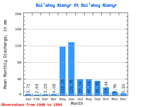
| Statistic | Jan | Feb | Mar | Apr | May | Jun | Jul | Aug | Sep | Oct | Nov | Dec | Annual |
|---|---|---|---|---|---|---|---|---|---|---|---|---|---|
| Mean | 3.71 | 2.67 | 3.03 | 4.08 | 118.03 | 128.95 | 39.13 | 40.13 | 35.35 | 19.44 | 9.96 | 5.50 | 412.04 |
| Standard Deviation | 2.33 | 1.97 | 2.39 | 3.03 | 58.60 | 71.28 | 22.71 | 24.35 | 15.09 | 6.18 | 5.14 | 2.51 | 77.81 |
| Min | 0.78 | 0.35 | 0.11 | 0.04 | 10.71 | 24.83 | 11.61 | 10.92 | 14.32 | 9.88 | 3.60 | 1.49 | 265.55 |
| Max | 10.91 | 6.52 | 10.64 | 16.51 | 228.34 | 274.21 | 105.85 | 102.47 | 73.80 | 39.18 | 33.29 | 12.94 | 641.82 |
| Coefficient of Variation | 0.63 | 0.74 | 0.79 | 0.74 | 0.50 | 0.55 | 0.58 | 0.61 | 0.43 | 0.32 | 0.52 | 0.46 | 0.19 |
 Return to R-Arctic Net Home Page