|
|
|||||||||||||||||
| Point ID: 6225 | Downloads | Plots | Site Data | Code: 3206 |
|
|
|||||||||||||||||
| Download | |
|---|---|
| Site Descriptor Information | Site Time Series Data |
| Link to all available data | |
| View: | Time Series | All |
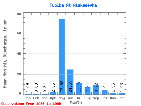
| Units: | m3/s |
| Statistic | Jan | Feb | Mar | Apr | May | Jun | Jul | Aug | Sep | Oct | Nov | Dec | Annual |
|---|---|---|---|---|---|---|---|---|---|---|---|---|---|
| Mean | 1.09 | 0.83 | 0.84 | 2.35 | 73.92 | 24.59 | 11.70 | 7.24 | 9.71 | 4.44 | 1.95 | 1.43 | 138.56 |
| Standard Deviation | 0.65 | 0.44 | 0.45 | 4.37 | 26.24 | 14.77 | 12.59 | 8.10 | 9.33 | 3.26 | 1.19 | 0.81 | 42.56 |
| Min | 0.27 | 0.19 | 0.14 | 0.18 | 0.89 | 4.64 | 1.60 | 1.92 | 2.12 | 0.99 | 0.31 | 0.36 | 71.64 |
| Max | 3.92 | 2.59 | 2.55 | 22.86 | 136.69 | 61.92 | 60.44 | 41.47 | 43.56 | 16.23 | 6.50 | 5.06 | 271.88 |
| Coefficient of Variation | 0.59 | 0.53 | 0.54 | 1.86 | 0.35 | 0.60 | 1.08 | 1.12 | 0.96 | 0.73 | 0.61 | 0.56 | 0.31 |
 Return to R-Arctic Net Home Page