|
|
|||||||||||||||||
| Point ID: 6224 | Downloads | Plots | Site Data | Code: 3202 |
|
|
|||||||||||||||||
| Download | |
|---|---|
| Site Descriptor Information | Site Time Series Data |
| Link to all available data | |
| View: | Time Series | All |
| Units: | m3/s |
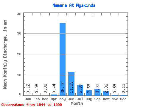
| Statistic | Jan | Feb | Mar | Apr | May | Jun | Jul | Aug | Sep | Oct | Nov | Dec | Annual |
|---|---|---|---|---|---|---|---|---|---|---|---|---|---|
| Mean | 0.12 | 0.08 | 0.08 | 0.44 | 35.09 | 11.33 | 5.09 | 2.59 | 3.02 | 2.06 | 0.39 | 0.19 | 60.59 |
| Standard Deviation | 0.05 | 0.05 | 0.05 | 0.90 | 20.25 | 9.23 | 7.26 | 2.99 | 5.10 | 3.27 | 0.20 | 0.09 | 32.58 |
| Min | 0.02 | 0.00 | 0.02 | 0.04 | 7.92 | 2.20 | 0.63 | 0.44 | 0.15 | 0.11 | 0.03 | 0.01 | 20.88 |
| Max | 0.25 | 0.25 | 0.26 | 4.54 | 109.22 | 55.90 | 37.59 | 16.94 | 37.32 | 21.13 | 1.20 | 0.44 | 208.02 |
| Coefficient of Variation | 0.46 | 0.57 | 0.64 | 2.04 | 0.58 | 0.81 | 1.43 | 1.15 | 1.69 | 1.59 | 0.53 | 0.47 | 0.54 |
 Return to R-Arctic Net Home Page