|
|
|||||||||||||||||
| Point ID: 6222 | Downloads | Plots | Site Data | Code: 3198 |
|
|
|||||||||||||||||
| Download | |
|---|---|
| Site Descriptor Information | Site Time Series Data |
| Link to all available data | |
| View: | Time Series | All |
| Units: | m3/s |
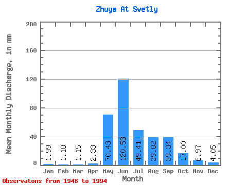
| Statistic | Jan | Feb | Mar | Apr | May | Jun | Jul | Aug | Sep | Oct | Nov | Dec | Annual |
|---|---|---|---|---|---|---|---|---|---|---|---|---|---|
| Mean | 1.99 | 1.19 | 1.15 | 2.33 | 70.42 | 120.53 | 49.40 | 39.82 | 39.34 | 16.99 | 6.97 | 4.05 | 353.57 |
| Standard Deviation | 0.91 | 0.57 | 0.59 | 2.44 | 23.62 | 35.71 | 24.07 | 22.02 | 19.73 | 6.05 | 2.38 | 1.78 | 71.48 |
| Min | 0.11 | 0.02 | 0.07 | 0.19 | 26.78 | 48.59 | 18.95 | 11.80 | 10.71 | 7.32 | 2.84 | 0.56 | 209.22 |
| Max | 4.98 | 2.97 | 3.40 | 14.72 | 113.49 | 216.99 | 120.20 | 97.28 | 97.40 | 36.40 | 12.88 | 8.67 | 532.85 |
| Coefficient of Variation | 0.45 | 0.48 | 0.51 | 1.05 | 0.34 | 0.30 | 0.49 | 0.55 | 0.50 | 0.36 | 0.34 | 0.44 | 0.20 |
 Return to R-Arctic Net Home Page