|
|
|||||||||||||||||
| Point ID: 6212 | Downloads | Plots | Site Data | Code: 3159 |
|
|
|||||||||||||||||
| Download | |
|---|---|
| Site Descriptor Information | Site Time Series Data |
| Link to all available data | |
| View: | Time Series | All |
| Units: | m3/s |
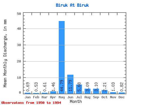
| Statistic | Jan | Feb | Mar | Apr | May | Jun | Jul | Aug | Sep | Oct | Nov | Dec | Annual |
|---|---|---|---|---|---|---|---|---|---|---|---|---|---|
| Mean | 0.69 | 0.53 | 0.61 | 1.46 | 44.78 | 11.79 | 5.68 | 3.09 | 3.10 | 2.21 | 1.03 | 0.82 | 75.05 |
| Standard Deviation | 0.28 | 0.21 | 0.28 | 2.08 | 24.29 | 7.38 | 7.57 | 3.13 | 2.38 | 1.32 | 0.43 | 0.35 | 36.38 |
| Min | 0.25 | 0.21 | 0.07 | 0.10 | 9.69 | 3.74 | 1.24 | 0.90 | 0.80 | 0.65 | 0.49 | 0.32 | 27.45 |
| Max | 1.74 | 1.23 | 1.42 | 13.20 | 114.57 | 41.69 | 48.87 | 19.60 | 12.37 | 6.57 | 2.38 | 2.07 | 203.68 |
| Coefficient of Variation | 0.40 | 0.40 | 0.46 | 1.43 | 0.54 | 0.63 | 1.33 | 1.01 | 0.77 | 0.60 | 0.42 | 0.42 | 0.48 |
 Return to R-Arctic Net Home Page