|
|
|||||||||||||||||
| Point ID: 6206 | Downloads | Plots | Site Data | Code: 3153 |
|
|
|||||||||||||||||
| Download | |
|---|---|
| Site Descriptor Information | Site Time Series Data |
| Link to all available data | |
| View: | Time Series | All |
| Units: | m3/s |
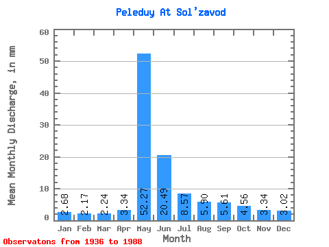
| Statistic | Jan | Feb | Mar | Apr | May | Jun | Jul | Aug | Sep | Oct | Nov | Dec | Annual |
|---|---|---|---|---|---|---|---|---|---|---|---|---|---|
| Mean | 2.68 | 2.19 | 2.24 | 3.34 | 52.26 | 20.48 | 8.57 | 5.90 | 5.61 | 4.56 | 3.34 | 3.02 | 113.47 |
| Standard Deviation | 0.73 | 0.58 | 0.62 | 2.46 | 15.97 | 11.51 | 3.18 | 2.22 | 2.62 | 1.83 | 1.08 | 0.81 | 29.05 |
| Min | 1.82 | 1.34 | 1.24 | 1.35 | 20.48 | 2.29 | 3.80 | 3.31 | 3.13 | 1.96 | 1.67 | 1.92 | 59.23 |
| Max | 4.57 | 3.53 | 3.60 | 13.57 | 92.16 | 60.80 | 16.13 | 15.10 | 20.01 | 12.52 | 7.49 | 5.42 | 203.55 |
| Coefficient of Variation | 0.27 | 0.27 | 0.28 | 0.73 | 0.31 | 0.56 | 0.37 | 0.38 | 0.47 | 0.40 | 0.32 | 0.27 | 0.26 |
 Return to R-Arctic Net Home Page