|
|
|||||||||||||||||
| Point ID: 6203 | Downloads | Plots | Site Data | Code: 3150 |
|
|
|||||||||||||||||
| Download | |
|---|---|
| Site Descriptor Information | Site Time Series Data |
| Link to all available data | |
| View: | Time Series | All |
| Units: | m3/s |
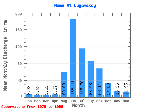
| Statistic | Jan | Feb | Mar | Apr | May | Jun | Jul | Aug | Sep | Oct | Nov | Dec | Annual |
|---|---|---|---|---|---|---|---|---|---|---|---|---|---|
| Mean | 8.38 | 5.68 | 5.61 | 6.67 | 60.68 | 185.41 | 115.68 | 86.47 | 68.11 | 34.60 | 15.26 | 11.95 | 606.70 |
| Standard Deviation | 2.18 | 1.32 | 1.11 | 2.39 | 21.68 | 35.16 | 43.24 | 29.34 | 20.74 | 8.98 | 4.97 | 3.28 | 96.89 |
| Min | 4.86 | 3.26 | 4.00 | 4.23 | 32.02 | 140.87 | 49.63 | 40.75 | 39.16 | 20.23 | 9.71 | 6.46 | 424.32 |
| Max | 15.28 | 7.84 | 8.08 | 14.51 | 106.68 | 278.92 | 196.48 | 161.55 | 121.57 | 53.71 | 27.47 | 21.83 | 765.32 |
| Coefficient of Variation | 0.26 | 0.23 | 0.20 | 0.36 | 0.36 | 0.19 | 0.37 | 0.34 | 0.30 | 0.26 | 0.33 | 0.28 | 0.16 |
 Return to R-Arctic Net Home Page