|
|
|||||||||||||||||
| Point ID: 6199 | Downloads | Plots | Site Data | Code: 3144 |
|
|
|||||||||||||||||
| Download | |
|---|---|
| Site Descriptor Information | Site Time Series Data |
| Link to all available data | |
| View: | Time Series | All |
| Units: | m3/s |
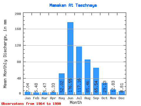
| Statistic | Jan | Feb | Mar | Apr | May | Jun | Jul | Aug | Sep | Oct | Nov | Dec | Annual |
|---|---|---|---|---|---|---|---|---|---|---|---|---|---|
| Mean | 7.04 | 5.52 | 5.47 | 6.33 | 52.01 | 176.55 | 117.14 | 85.45 | 65.54 | 29.12 | 12.83 | 8.80 | 565.71 |
| Standard Deviation | 1.37 | 1.32 | 1.27 | 2.05 | 21.06 | 32.82 | 43.25 | 30.27 | 23.34 | 6.13 | 2.64 | 1.99 | 92.66 |
| Min | 4.37 | 2.61 | 3.31 | 3.09 | 22.63 | 117.82 | 52.92 | 33.94 | 37.35 | 15.82 | 6.09 | 4.86 | 396.72 |
| Max | 9.45 | 8.61 | 8.02 | 12.54 | 93.80 | 248.80 | 206.94 | 142.49 | 132.37 | 44.04 | 17.88 | 12.75 | 815.95 |
| Coefficient of Variation | 0.20 | 0.24 | 0.23 | 0.32 | 0.41 | 0.19 | 0.37 | 0.35 | 0.36 | 0.21 | 0.21 | 0.23 | 0.16 |
 Return to R-Arctic Net Home Page