|
|
|||||||||||||||||
| Point ID: 6198 | Downloads | Plots | Site Data | Code: 3138 |
|
|
|||||||||||||||||
| Download | |
|---|---|
| Site Descriptor Information | Site Time Series Data |
| Link to all available data | |
| View: | Time Series | All |
| Units: | m3/s |
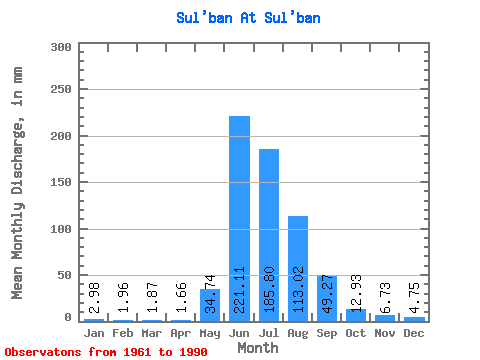
| Statistic | Jan | Feb | Mar | Apr | May | Jun | Jul | Aug | Sep | Oct | Nov | Dec | Annual |
|---|---|---|---|---|---|---|---|---|---|---|---|---|---|
| Mean | 2.98 | 1.98 | 1.87 | 1.66 | 34.73 | 221.11 | 185.77 | 113.00 | 49.27 | 12.93 | 6.73 | 4.75 | 599.91 |
| Standard Deviation | 1.26 | 1.04 | 0.72 | 0.54 | 37.22 | 72.90 | 79.64 | 54.92 | 18.54 | 3.96 | 1.75 | 1.72 | 108.81 |
| Min | 1.31 | 0.99 | 0.99 | 1.11 | 1.88 | 149.35 | 45.91 | 39.53 | 26.48 | 9.09 | 4.20 | 2.58 | 424.24 |
| Max | 5.45 | 5.29 | 4.02 | 3.49 | 122.10 | 450.51 | 306.69 | 248.03 | 98.74 | 24.26 | 11.05 | 9.21 | 838.31 |
| Coefficient of Variation | 0.42 | 0.52 | 0.39 | 0.33 | 1.07 | 0.33 | 0.43 | 0.49 | 0.38 | 0.31 | 0.26 | 0.36 | 0.18 |
 Return to R-Arctic Net Home Page