|
|
|||||||||||||||||
| Point ID: 6197 | Downloads | Plots | Site Data | Code: 3136 |
|
|
|||||||||||||||||
| Download | |
|---|---|
| Site Descriptor Information | Site Time Series Data |
| Link to all available data | |
| View: | Time Series | All |
| Units: | m3/s |
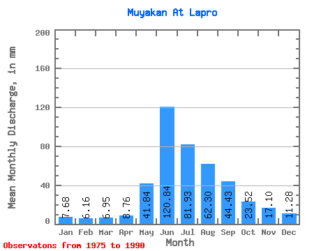
| Statistic | Jan | Feb | Mar | Apr | May | Jun | Jul | Aug | Sep | Oct | Nov | Dec | Annual |
|---|---|---|---|---|---|---|---|---|---|---|---|---|---|
| Mean | 7.68 | 6.21 | 6.95 | 8.76 | 41.83 | 120.84 | 81.91 | 62.29 | 44.43 | 23.52 | 17.10 | 11.28 | 434.01 |
| Standard Deviation | 2.05 | 1.70 | 2.27 | 1.74 | 22.86 | 28.59 | 38.83 | 19.32 | 14.85 | 7.26 | 5.08 | 4.44 | 75.39 |
| Min | 4.41 | 3.64 | 2.92 | 5.73 | 18.85 | 81.18 | 25.07 | 30.21 | 27.68 | 12.75 | 9.61 | 6.80 | 257.79 |
| Max | 12.75 | 10.35 | 12.43 | 12.03 | 87.30 | 177.29 | 149.97 | 105.83 | 79.00 | 40.71 | 30.90 | 24.64 | 552.21 |
| Coefficient of Variation | 0.27 | 0.27 | 0.33 | 0.20 | 0.55 | 0.24 | 0.47 | 0.31 | 0.33 | 0.31 | 0.30 | 0.39 | 0.17 |
 Return to R-Arctic Net Home Page