|
|
|||||||||||||||||
| Point ID: 6189 | Downloads | Plots | Site Data | Code: 3127 |
|
|
|||||||||||||||||
| Download | |
|---|---|
| Site Descriptor Information | Site Time Series Data |
| Link to all available data | |
| View: | Time Series | All |
| Units: | m3/s |
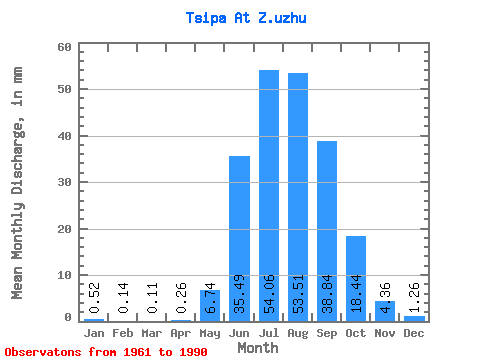
| Statistic | Jan | Feb | Mar | Apr | May | Jun | Jul | Aug | Sep | Oct | Nov | Dec | Annual |
|---|---|---|---|---|---|---|---|---|---|---|---|---|---|
| Mean | 0.52 | 0.15 | 0.11 | 0.26 | 6.74 | 35.49 | 54.05 | 53.50 | 38.84 | 18.44 | 4.36 | 1.26 | 212.48 |
| Standard Deviation | 0.58 | 0.18 | 0.17 | 0.33 | 4.33 | 15.70 | 24.91 | 33.14 | 21.53 | 11.75 | 2.85 | 0.75 | 85.51 |
| Min | 0.00 | 0.00 | 0.00 | 0.00 | 0.36 | 14.85 | 8.70 | 7.19 | 12.78 | 4.60 | 0.12 | 0.01 | 57.40 |
| Max | 2.69 | 0.86 | 0.97 | 1.76 | 21.80 | 72.78 | 96.65 | 135.27 | 95.87 | 62.14 | 15.10 | 3.31 | 402.37 |
| Coefficient of Variation | 1.12 | 1.24 | 1.54 | 1.24 | 0.64 | 0.44 | 0.46 | 0.62 | 0.55 | 0.64 | 0.65 | 0.59 | 0.40 |
 Return to R-Arctic Net Home Page