|
|
|||||||||||||||||
| Point ID: 6168 | Downloads | Plots | Site Data | Code: 3093 |
|
|
|||||||||||||||||
| Download | |
|---|---|
| Site Descriptor Information | Site Time Series Data |
| Link to all available data | |
| View: | Time Series | All |
| Units: | m3/s |
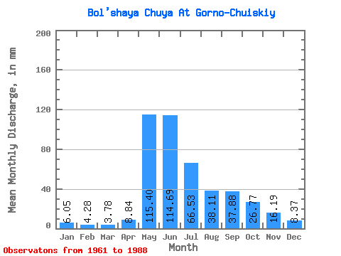
| Statistic | Jan | Feb | Mar | Apr | May | Jun | Jul | Aug | Sep | Oct | Nov | Dec | Annual |
|---|---|---|---|---|---|---|---|---|---|---|---|---|---|
| Mean | 6.04 | 4.31 | 3.78 | 8.84 | 115.38 | 114.69 | 66.52 | 38.11 | 37.88 | 26.76 | 16.19 | 8.37 | 445.07 |
| Standard Deviation | 1.97 | 1.07 | 1.30 | 9.31 | 38.59 | 46.54 | 23.57 | 10.88 | 11.88 | 5.54 | 6.29 | 2.77 | 52.87 |
| Min | 2.92 | 2.86 | 1.65 | 1.68 | 60.72 | 59.21 | 27.69 | 25.06 | 27.76 | 20.07 | 5.88 | 3.80 | 382.32 |
| Max | 8.88 | 6.23 | 5.44 | 28.82 | 169.47 | 182.89 | 93.80 | 55.28 | 64.91 | 34.03 | 24.69 | 12.87 | 543.10 |
| Coefficient of Variation | 0.33 | 0.25 | 0.34 | 1.05 | 0.33 | 0.41 | 0.35 | 0.28 | 0.31 | 0.21 | 0.39 | 0.33 | 0.12 |
 Return to R-Arctic Net Home Page