|
|
|||||||||||||||||
| Point ID: 6163 | Downloads | Plots | Site Data | Code: 3083 |
|
|
|||||||||||||||||
| Download | |
|---|---|
| Site Descriptor Information | Site Time Series Data |
| Link to all available data | |
| View: | Time Series | All |
| Units: | m3/s |
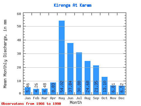
| Statistic | Jan | Feb | Mar | Apr | May | Jun | Jul | Aug | Sep | Oct | Nov | Dec | Annual |
|---|---|---|---|---|---|---|---|---|---|---|---|---|---|
| Mean | 5.46 | 4.29 | 4.48 | 8.83 | 54.01 | 37.84 | 30.88 | 24.68 | 21.35 | 13.10 | 6.81 | 6.52 | 217.95 |
| Standard Deviation | 1.35 | 1.20 | 1.40 | 5.66 | 12.91 | 12.66 | 20.92 | 14.90 | 10.48 | 5.43 | 2.01 | 1.75 | 52.53 |
| Min | 3.05 | 2.93 | 2.30 | 3.74 | 30.10 | 13.88 | 10.84 | 11.13 | 9.18 | 5.81 | 2.67 | 3.20 | 155.70 |
| Max | 8.60 | 8.08 | 7.91 | 26.93 | 78.26 | 68.32 | 118.75 | 69.55 | 50.63 | 25.53 | 9.69 | 9.90 | 374.40 |
| Coefficient of Variation | 0.25 | 0.28 | 0.31 | 0.64 | 0.24 | 0.34 | 0.68 | 0.60 | 0.49 | 0.41 | 0.29 | 0.27 | 0.24 |
 Return to R-Arctic Net Home Page