|
|
|||||||||||||||||
| Point ID: 616 | Downloads | Plots | Site Data | Code: 07AF005 |
|
|
|||||||||||||||||
| Download | |
|---|---|
| Site Descriptor Information | Site Time Series Data |
| Link to all available data | |
| View: | Time Series | All |
| Units: | m3/s |
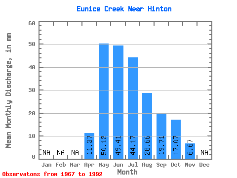
| Statistic | Jan | Feb | Mar | Apr | May | Jun | Jul | Aug | Sep | Oct | Nov | Dec | Annual |
|---|---|---|---|---|---|---|---|---|---|---|---|---|---|
| Mean | 11.38 | 50.06 | 49.37 | 44.09 | 28.61 | 19.77 | 17.07 | 6.67 | |||||
| Standard Deviation | 6.83 | 33.77 | 39.85 | 31.96 | 20.69 | 13.29 | 11.72 | 2.36 | |||||
| Min | 1.67 | 10.96 | 11.82 | 10.96 | 7.83 | 6.21 | 5.64 | 5.00 | |||||
| Max | 26.83 | 141.10 | 200.08 | 131.71 | 80.97 | 46.53 | 57.16 | 8.34 | |||||
| Coefficient of Variation | 0.60 | 0.68 | 0.81 | 0.72 | 0.72 | 0.67 | 0.69 | 0.35 |
 Return to R-Arctic Net Home Page