|
|
|||||||||||||||||
| Point ID: 6159 | Downloads | Plots | Site Data | Code: 3077 |
|
|
|||||||||||||||||
| Download | |
|---|---|
| Site Descriptor Information | Site Time Series Data |
| Link to all available data | |
| View: | Time Series | All |
| Units: | m3/s |
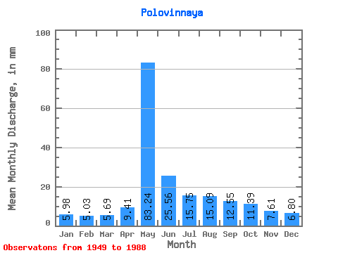
| Statistic | Jan | Feb | Mar | Apr | May | Jun | Jul | Aug | Sep | Oct | Nov | Dec | Annual |
|---|---|---|---|---|---|---|---|---|---|---|---|---|---|
| Mean | 5.98 | 5.08 | 5.70 | 9.41 | 83.23 | 25.56 | 15.74 | 15.09 | 12.55 | 11.38 | 7.62 | 6.80 | 202.66 |
| Standard Deviation | 1.88 | 1.53 | 1.57 | 5.74 | 22.28 | 12.03 | 7.69 | 8.95 | 4.51 | 3.76 | 2.40 | 2.17 | 40.83 |
| Min | 3.06 | 2.79 | 3.21 | 4.29 | 31.83 | 9.04 | 6.73 | 6.12 | 5.78 | 5.51 | 4.29 | 4.13 | 118.88 |
| Max | 10.25 | 8.51 | 9.79 | 30.81 | 132.37 | 65.32 | 38.56 | 52.80 | 25.62 | 21.88 | 14.52 | 13.47 | 312.59 |
| Coefficient of Variation | 0.31 | 0.30 | 0.28 | 0.61 | 0.27 | 0.47 | 0.49 | 0.59 | 0.36 | 0.33 | 0.32 | 0.32 | 0.20 |
 Return to R-Arctic Net Home Page