|
|
|||||||||||||||||
| Point ID: 6154 | Downloads | Plots | Site Data | Code: 3068 |
|
|
|||||||||||||||||
| Download | |
|---|---|
| Site Descriptor Information | Site Time Series Data |
| Link to all available data | |
| View: | Time Series | All |
| Units: | m3/s |
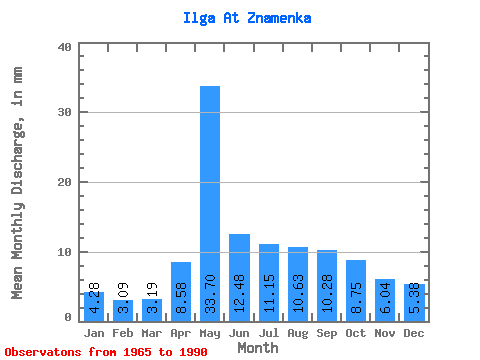
| Statistic | Jan | Feb | Mar | Apr | May | Jun | Jul | Aug | Sep | Oct | Nov | Dec | Annual |
|---|---|---|---|---|---|---|---|---|---|---|---|---|---|
| Mean | 4.28 | 3.12 | 3.19 | 8.58 | 33.70 | 12.48 | 11.15 | 10.63 | 10.28 | 8.75 | 6.04 | 5.38 | 117.59 |
| Standard Deviation | 1.79 | 1.20 | 1.20 | 7.41 | 14.86 | 5.43 | 6.61 | 6.26 | 5.61 | 4.56 | 2.78 | 2.29 | 32.55 |
| Min | 1.48 | 0.88 | 1.14 | 2.31 | 10.57 | 4.23 | 3.15 | 2.19 | 2.58 | 2.06 | 2.05 | 2.04 | 63.64 |
| Max | 8.63 | 5.78 | 5.53 | 34.10 | 66.60 | 26.47 | 27.31 | 26.15 | 25.24 | 19.84 | 13.47 | 10.85 | 189.90 |
| Coefficient of Variation | 0.42 | 0.38 | 0.38 | 0.86 | 0.44 | 0.43 | 0.59 | 0.59 | 0.55 | 0.52 | 0.46 | 0.42 | 0.28 |
 Return to R-Arctic Net Home Page