|
|
|||||||||||||||||
| Point ID: 6153 | Downloads | Plots | Site Data | Code: 3065 |
|
|
|||||||||||||||||
| Download | |
|---|---|
| Site Descriptor Information | Site Time Series Data |
| Link to all available data | |
| View: | Time Series | All |
| Units: | m3/s |
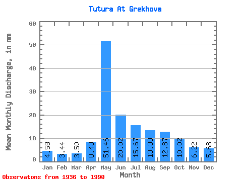
| Statistic | Jan | Feb | Mar | Apr | May | Jun | Jul | Aug | Sep | Oct | Nov | Dec | Annual |
|---|---|---|---|---|---|---|---|---|---|---|---|---|---|
| Mean | 4.58 | 3.47 | 3.50 | 8.43 | 51.45 | 20.02 | 15.67 | 13.38 | 12.87 | 10.02 | 6.22 | 5.67 | 154.38 |
| Standard Deviation | 1.81 | 1.31 | 1.30 | 8.09 | 18.21 | 12.24 | 10.20 | 8.75 | 7.08 | 4.83 | 3.20 | 2.35 | 42.06 |
| Min | 1.62 | 1.20 | 1.01 | 1.93 | 18.07 | 6.68 | 3.77 | 3.00 | 3.33 | 2.98 | 1.96 | 1.87 | 86.37 |
| Max | 8.03 | 6.22 | 6.34 | 34.50 | 89.77 | 66.81 | 59.97 | 47.90 | 37.60 | 23.91 | 13.44 | 11.43 | 262.07 |
| Coefficient of Variation | 0.40 | 0.38 | 0.37 | 0.96 | 0.35 | 0.61 | 0.65 | 0.65 | 0.55 | 0.48 | 0.51 | 0.41 | 0.27 |
 Return to R-Arctic Net Home Page