|
|
|||||||||||||||||
| Point ID: 6152 | Downloads | Plots | Site Data | Code: 3063 |
|
|
|||||||||||||||||
| Download | |
|---|---|
| Site Descriptor Information | Site Time Series Data |
| Link to all available data | |
| View: | Time Series | All |
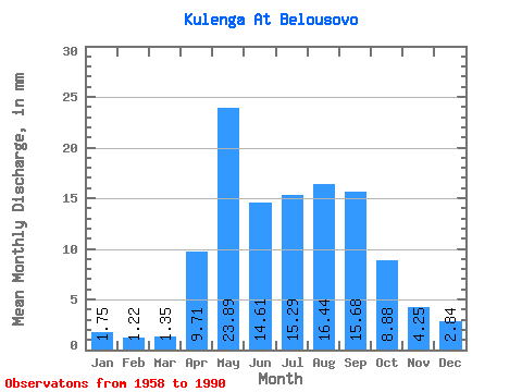
| Units: | m3/s |
| Statistic | Jan | Feb | Mar | Apr | May | Jun | Jul | Aug | Sep | Oct | Nov | Dec | Annual |
|---|---|---|---|---|---|---|---|---|---|---|---|---|---|
| Mean | 1.75 | 1.23 | 1.35 | 9.71 | 23.88 | 14.61 | 15.29 | 16.44 | 15.68 | 8.87 | 4.25 | 2.84 | 115.80 |
| Standard Deviation | 1.25 | 0.94 | 1.02 | 9.96 | 13.60 | 13.68 | 10.29 | 13.27 | 13.34 | 5.61 | 2.74 | 1.93 | 46.98 |
| Min | 0.09 | 0.08 | 0.03 | 0.33 | 7.08 | 1.93 | 2.00 | 1.77 | 1.78 | 1.49 | 0.71 | 0.45 | 38.11 |
| Max | 5.57 | 4.03 | 4.05 | 39.19 | 57.55 | 58.84 | 37.04 | 56.58 | 67.83 | 21.06 | 10.87 | 7.79 | 228.86 |
| Coefficient of Variation | 0.71 | 0.77 | 0.75 | 1.03 | 0.57 | 0.94 | 0.67 | 0.81 | 0.85 | 0.63 | 0.64 | 0.68 | 0.41 |
 Return to R-Arctic Net Home Page