|
|
|||||||||||||||||
| Point ID: 6067 | Downloads | Plots | Site Data | Code: 7174 |
|
|
|||||||||||||||||
| Download | |
|---|---|
| Site Descriptor Information | Site Time Series Data |
| Link to all available data | |
| View: | Time Series | All |
| Units: | m3/s |
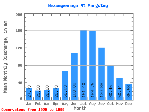
| Statistic | Jan | Feb | Mar | Apr | May | Jun | Jul | Aug | Sep | Oct | Nov | Dec | Annual |
|---|---|---|---|---|---|---|---|---|---|---|---|---|---|
| Mean | 27.79 | 21.77 | 22.59 | 26.73 | 66.02 | 108.00 | 161.37 | 159.74 | 120.88 | 80.44 | 50.44 | 36.68 | 882.65 |
| Standard Deviation | 7.85 | 5.74 | 5.27 | 6.25 | 14.08 | 35.80 | 81.59 | 66.09 | 45.16 | 20.11 | 13.38 | 10.82 | 206.81 |
| Min | 16.80 | 13.76 | 13.39 | 14.10 | 44.24 | 50.82 | 66.95 | 65.51 | 53.11 | 47.26 | 24.14 | 20.74 | 517.88 |
| Max | 44.11 | 36.60 | 32.95 | 38.50 | 100.16 | 212.19 | 472.59 | 351.82 | 223.62 | 124.32 | 78.14 | 57.63 | 1295.02 |
| Coefficient of Variation | 0.28 | 0.26 | 0.23 | 0.23 | 0.21 | 0.33 | 0.51 | 0.41 | 0.37 | 0.25 | 0.27 | 0.29 | 0.23 |
 Return to R-Arctic Net Home Page