|
|
|||||||||||||||||
| Point ID: 6066 | Downloads | Plots | Site Data | Code: 7172 |
|
|
|||||||||||||||||
| Download | |
|---|---|
| Site Descriptor Information | Site Time Series Data |
| Link to all available data | |
| View: | Time Series | All |
| Units: | m3/s |
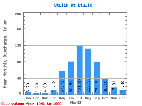
| Statistic | Jan | Feb | Mar | Apr | May | Jun | Jul | Aug | Sep | Oct | Nov | Dec | Annual |
|---|---|---|---|---|---|---|---|---|---|---|---|---|---|
| Mean | 6.70 | 4.40 | 4.89 | 11.43 | 57.70 | 80.91 | 121.07 | 112.29 | 79.19 | 38.09 | 17.31 | 11.30 | 539.30 |
| Standard Deviation | 2.10 | 1.60 | 1.63 | 5.71 | 21.89 | 33.56 | 67.23 | 41.70 | 36.25 | 11.30 | 5.46 | 3.27 | 120.34 |
| Min | 1.90 | 1.65 | 1.48 | 4.78 | 20.66 | 27.57 | 32.67 | 37.70 | 13.89 | 4.94 | 9.41 | 2.18 | 204.15 |
| Max | 14.13 | 9.03 | 10.72 | 32.97 | 161.41 | 158.93 | 376.99 | 241.55 | 234.33 | 62.55 | 30.00 | 20.19 | 854.00 |
| Coefficient of Variation | 0.31 | 0.36 | 0.33 | 0.50 | 0.38 | 0.41 | 0.56 | 0.37 | 0.46 | 0.30 | 0.32 | 0.29 | 0.22 |
 Return to R-Arctic Net Home Page