|
|
|||||||||||||||||
| Point ID: 6064 | Downloads | Plots | Site Data | Code: 7161 |
|
|
|||||||||||||||||
| Download | |
|---|---|
| Site Descriptor Information | Site Time Series Data |
| Link to all available data | |
| View: | Time Series | All |
| Units: | m3/s |
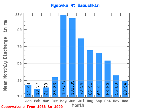
| Statistic | Jan | Feb | Mar | Apr | May | Jun | Jul | Aug | Sep | Oct | Nov | Dec | Annual |
|---|---|---|---|---|---|---|---|---|---|---|---|---|---|
| Mean | 24.47 | 19.53 | 21.79 | 33.84 | 107.77 | 103.85 | 79.53 | 65.91 | 62.41 | 53.49 | 35.89 | 29.93 | 616.79 |
| Standard Deviation | 6.97 | 6.65 | 6.14 | 9.78 | 33.26 | 57.46 | 39.47 | 23.75 | 25.95 | 16.24 | 10.45 | 7.37 | 125.03 |
| Min | 6.56 | 3.88 | 3.90 | 2.75 | 42.74 | 32.79 | 36.18 | 26.43 | 29.18 | 26.60 | 3.43 | 13.66 | 336.68 |
| Max | 39.90 | 37.97 | 37.42 | 75.70 | 189.77 | 432.57 | 209.27 | 133.90 | 168.39 | 105.52 | 61.11 | 44.69 | 927.64 |
| Coefficient of Variation | 0.28 | 0.34 | 0.28 | 0.29 | 0.31 | 0.55 | 0.50 | 0.36 | 0.42 | 0.30 | 0.29 | 0.25 | 0.20 |
 Return to R-Arctic Net Home Page